Geography, Weather, & Wildlife of Afghanistan
WARNING: Afghanistan is currently unstable, please read this travel warning before going!
Geography

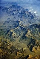
Mountains from the air
Afghanistan is a landlocked country that sits between the Middle East, Central Asia, and South Asia. It shares land borders with Iran to the west, Pakistan to the south and east, China to the east, and Tajikistan, Uzbekistan, and Turkmenistan to the north.
Much of Afghanistan is desert or mountain. The Hindu Kush Mountains in the country's east are some of the highest in the world. In this range and from this range there are numerous rivers and this region is the most densely populated part of the country. Outside the deserts and mountains, there are a few lower elevated valleys that are quite fertile and livable, primarily found in the country's northwest.
Weather
Afghanistan has a number of weather variations based upon elevation and seasons. As a fairly mountainous country the elevation changes create vastly differing temperatures and weather patterns. Winters (November to February) in the mountains are very cold and can receive a great deal of snow; temperatures in the mountains in winter can average 15° F (-9° C), while in the lower valleys temperatures tend to move below and above the freezing point (32° F (0° C)). Summers in the mountains tend to warm up, but at elevation evening temperatures are still very low and can be near or below freezing, although day time temperatures can rise significantly. Again the valleys and low lands are warmer as Kabul receives daily highs of about 90° F (32° C) with nights falling to about 55° F (13° C) during the summer months. Springs and falls (autumns) are less predictable, especially in the mountains where snow can arrive in the fall and melting snow can cause trouble in spring.