Geography, Weather, & Wildlife of Bhutan
Geography

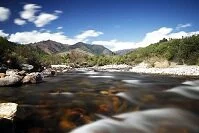
River in the mountains
Bhutan is a small landlocked country in the Himalaya Mountains. To its north is Tibet, a region in China, and to its south is the country of India.
Bhutan is a very high country in that much of its northern half is covered with the Himalaya Mountains. From these peaks, the country declines in elevation moving south as the country is divided by numerous rivers and valleys. Most of the population lives in the lower elevated valleys.
Weather

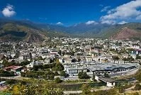
Thimpu
Bhutan has one of the world's most extreme elevation changes and for a small country that is even more pronounced when you try to predict the weather. The Himalayas are cold year round and most peaks never lose their snow. The in between elevations, that are in the Himalaya valleys and at lower elevations, such as the capital of Thimphu get more varies seasons. In these areas there are three distinct seasons, the summer or hot season (March to about June) has temperatures of 65° F (18° C), the monsoon or rainy season (about June to September) experiences daily highs of about 75° F (24° C) as rain is common, and the winters (October to February) generally get below freezing at night, but can get as warm as 60° F (16° C) during the day. Further south and at the lower elevations the temperatures get hotter, but the seasons and rain coincides with that of the capital. In these lower elevations the temperatures rarely drop below about 60° F (15° C) in the winter and generally reach no hotter than about 85° F (30° C) in the summers, except in the hottest valleys, which can reach 100° F (40° C) on occasion.