Geography, Weather, & Wildlife of Cuba
WARNING: International disputes with Cuba are ongoing, please read this travel warning before going!
Geography

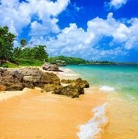
Rocks on the beach
Cuba is the largest island in the Caribbean Sea and is a part of the Greater Antilles. Although it has no land borders, Cuba lies close to a number of island nations and territories. To Cuba's north is both Florida (a state in the United States) and the Bahamas. To the south are both the Cayman Islands (a territory of the United Kingdom) and Jamaica. To Cuba's east are Haiti and the United Kingdom's territory of Turks & Caicos.
Cuba is a long, but narrow island with a number of small mountain ranges running along it including Sierra Maestra, the Central Range, and the Sierra de los Organos. However, much of the island is flatland with an incredibly long coastline. The island is quite densely populated throughout.
Weather
Cuba is a fairly mountainous country, however these mountains rarely effect the country's weather patterns. Generally speaking, Cuba has a temperature range from about 72-80° F (22-27° C) throughout the year, with the greatest variations coming in rain and wind. The dry season lasts from about November to April and the wet season tends to last from about May to October. Wet season also nearly coincides with hurricane season, which lasts from June to November. During this time Cuba is highly susceptible to hurricanes and other tropical storms that contain high winds and rain.