Geography, Weather, & Wildlife of Iceland
Geography

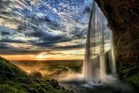
Seljalandsfoss Waterfall
Iceland is an island between the Atlantic Ocean and Arctic Ocean. It is fairly isolated; its closest neighbors are Greenland to the west and the Faroe Islands to the southeast (both governed by Denmark).
Geographically, Iceland is a country formed by volcanic activity and thus is fairly mountainous. However, it also has a long coastline and numerous glacial fields. Between the ocean, volcanoes, and glaciers, the country is very unique and diverse geographically and geologically. The entire island is very sparsely populated outside of Reykjavik.
Weather

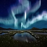
Northern lights
Despite Iceland's north latitude, the country is fairly temperate due to the North Atlantic Ocean gulf stream and the volcanic activity just beneath the surface. However, when currents from the northwest come in, temperatures can cool quickly and dramatically.
The average winter temperature in Reykjavik is right around the freezing point (31° F (0° C) as days are short and fog from the Atlantic can come in quickly, making it feel much cooler. In the north of Iceland temperatures tend to be lower, but most precipitation remains in the south, including much snow at elevation on the mountains.
Summer temperatures don't get overly warm, reaching daily highs of about 55° F (13° C) in Reykjavik. Days are long though and the clouds are infrequent during this time making it feel slightly warmer.