Geography, Weather, & Wildlife of Italy
Geography

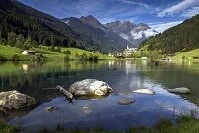
Muhlwald in the Alps
Italy is a peninsula that juts south into the Mediterranean Sea. Beyond the mainland peninsula, Italy also owns a few islands off its shores, including Sardinia to its west and Sicily to its southwest. Italy is bordered by France (west), Slovenia (east), Austria (northeast), and Switzerland (north).
Geographically, Italy is a very mountainous country with an extremely long coastline. In the north of the country are the Alps, which are very tall and many parts are inaccessible. From these mountains a number of large rivers flow south and east, many of which drain into the Adriatic Sea. This northern area is also very flat and very densely populated. From here moving north-south along the peninsula there is a "spine-like" mountain chain dividing the country. These mountains gradually rise and fall, making them fairly accessible as they slope down to the coasts, which are flat. Likewise, both Sardinia and Sicily are fairly mountainous, but accessible.
Weather

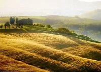
Tuscany
Italy is a fairly large country, but doesn't typically experience the extreme colds and snow outside the Alps. Although most of the country doesn't receive snow, the country's weather still varies due to the length of the country running north-south and due to the country's mountains. Winters (December-February) are cold and snowy in the Alps, with temperatures regularly below freezing, but in nearby Milan, snow is rare as the temperature averages about 40˚ F (5˚ C). The further south one travels the warmer the weather gets except in the mountains running the length of the country, which are always cooler. Although many cities, including Rome, get snow, only towns and cities surrounded by mountains tend to get cold enough to sustain snow for weeks at a time. The island of Sicily and the southern part of the country tends to be warm year round, with the coldest days of winter still averaging 55˚ F (13˚ C).