Geography, Weather, & Wildlife of Montenegro
Geography

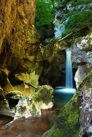
Bratimin waterfall
Montenegro is positioned on the Adriatic Sea in the Balkan Peninsula. It borders Bosnia & Herzegovina (northwest), Croatia (west), Albania (south), and Serbia (northeast).
Geographically, Montenegro is exactly as its name implies: "black mountains." Most of these mountains rise up in steep cliffs making transportation and settlement quite difficult or at least isolated. In the country's south and along the Adriatic Sea coast the land is flatter, but in many instances (particularly along the coast) the mountains rise up too quickly to allow expansion of any city. Only in Podgorica and the adjacent lowlands do any substantial communities exist.
Weather

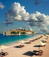
Sveti Stefan
For a small country, Montenegro's seasons are very distinct due to geographical variations and they receive a large amount of precipitation year-round, especially in the winter. Winters (December-February) can be cold as much of the country receives snow; Zabljak and other mountain villages can get over 10 feet of snow (3 meters) over the season. Meanwhile, the coast averages about 45˚ F (8˚ C) during this time and gets a lot of rain.
The spring and fall (autumn) tend to be warmer than the winter, but the mountains can still be impassable due to snow. During this time water temperatures also change; from May until about November water temperatures in the Adriatic average between 65-73˚ F (18-23˚ C), which warms up the air temperature as well.