Geography, Weather, & Wildlife of the Netherlands
Geography

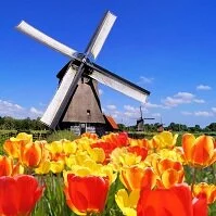
Tulips and a windmill
The Netherlands is located on the North Sea in the northwest corner of mainland Europe, a region commonly known as "Benelux," which is a combination of the names "Belgium," "Netherlands," and "Luxembourg." The Netherlands is bordered by Belgium (south) and Germany (east).
Geographically, the Netherlands is one of the world's lowest lying countries as much of it is actually below sea level. The country would be mostly under water if it weren't for the people's ability to "reclaim" land. In these, and in other areas, the country is very flat with a large number of rivers, creating a great agricultural environment.
Weather

Bridge in the winter
The Netherlands rarely experiences the cold, harsh winters that neighboring Germany gets regularly, although winds can make the country feel significantly cooler. Being on the water, the Netherlands gets a warming effect during the winters and a cooling effect during the summers, making the country relatively temperate.
Amsterdam averages 35° F (2° C) during the winter with lows many times sinking to below freezing (32° F (0° C)) and daily highs only getting a bit warmer than the average. Summers are much nicer as daily highs are at about 70° F (19° C), although again these temperatures do drop to the mid-50s (12-13° C) at night. Variations across the country are relatively minor due to the country's small size and flat landscape. The winds and rain can make it feel significantly cooler quite quickly as the country is generally cloudy and rain can arrive during any season.