Geography, Weather, & Wildlife of Nicaragua
Geography

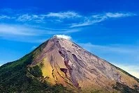
Conception Volcano
Nicaragua sits in the middle of Central America. The country borders Honduras in the north and in the south borders Costa Rica. Nicaragua stretches from the Pacific Ocean in the west to the Caribbean Sea in the east.
Despite Nicaragua's small size and its borders with both the Pacific Ocean and Caribbean Sea, the country is quite elevated and mountainous. These mountains tend to rise straight out of the ocean, but on the Caribbean Sea side, there is a plain, although it is quite forested. The mountains peak near the Pacific Ocean coast, where the large Lake Nicaragua stands; from this lake and the mountains, a number of rivers run east into the Caribbean Sea.
Weather
Nicaragua's temperatures and weather is very dependent on elevation and season. The country has two seasons, wet season from about May to November and dry season from about December to April. However, even with these two seasons, rainfall varies greatly as the Caribbean Sea coast tends to get rain year round and will annually get three to five times more rain than the Pacific Coast. The second major influence on the weather in Nicaragua is elevation. At sea level the days and nights are much hotter with temperatures rarely dipping below 70° F (21° C) at night and daily highs jumping another 10-20° F (6-11° C). As the elevation rises, temperatures drop, but no place ever reaches the freezing point, with the mountains only getting down to about 60° F (15° C) at night. There is a chance for hurricanes from about June to November, but most Caribbean Sea hurricanes miss them to the north.