Geography, Weather, & Wildlife of Slovenia
Geography

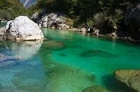
Soca River
Slovenia is located between a couple different regions. It can be considered a part of Southeastern Europe, southern Europe, or even Central Europe. Slovenia briefly touches the Adriatic Sea, but is nearly landlocked. The country is bordered by Italy (west), Croatia (south and east), Hungary (northeast), and Austria (north).
Geographically, the small country of Slovenia is incredibly diverse. Along much of the country's northern border and stretching south along the western part of the country are the Alps. A couple small rivers from these mountains run through the eastern and northeastern part of the country. In the southwest there is a small stretch of land that borders the Adriatic Sea, but this low land only lasts a short distance before rising into the mountains. None-the-less, this area is the most densely populated part of Slovenia.
Weather
Slovenia's seasons are very distinct due to geographical variations, but the entire country receives a great deal of rain and snow. Winters (December-February) can be cold in the Alps, but fairly temperate on the coast. Piran averages in the low 40s F (6˚ C) while the mountains average a couple degrees below freezing. The Alps also can get huge amounts of snow, delaying travel; most years the Alps get enough snow that the last of it doesn't melt until May or June.