Geography, Weather, & Wildlife of Timor Leste
Geography

Coastline
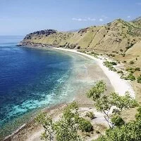
Timor-Leste (East Timor), the country, is geographically the same, the eastern part of Timor Island, which is an island in the southern island chain that makes up Indonesia. Indonesia is Timor-Leste's only land border as the western half of the island belongs to them. To the island's north is the Banda Sea and to the south is the Timor Sea.
Timor-Leste is fairly hilly and fertile as the country is well populated. However, there is little geographical variety to speak of in this tiny country.
Weather
Timor-Leste's weather is primarily based on the two seasons: wet and dry. The wet season runs from about December to April with high humidity and daily temperature averages of 85-95° F (29-35° C) with days generally getting hotter and night a bit cooler. The dry season (about May to November) is nearly as hot with temperatures averaging 70-90° F (21-33° C). However, the air is drier and there is little rain. The transition times between these seasons experience rapid increases and decreases in humidity.