Geography, Weather, & Wildlife of Guatemala
Geography

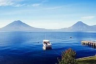
Lake Atitlan
Guatemala is at the northern end of Central America. To the country's north and west is Mexico, El Salvador is to the southeast, as is Honduras, and Belize is to the country's east. Guatemala borders the Pacific Ocean in the southwest, while it has a very short border with the Caribbean Sea in the east.
Guatemala is a fairly mountainous country as two ranges run across the country, including the Altos Cuchumatanes and the Sierra Madre Range, although none of the mountains are excessively high, the latter contains a number of volcanoes. The only place in the country where the land is actually at elevation is along the Pacific Ocean, although even here the mountains don't rise to excessive heights. In the far north, near Mexico is the lowest stretch of land, although this area is very forested and difficult to access.
Weather
Guatemala is fairly mountainous so temperatures and weather vary based upon season and elevation. Along the coasts and lowlands the weather is generally hot and humid with daily highs about 90° F (32° C) and nightly lows rarely dipping below 70° F (20° C). In most major cities that are at elevation, like Guatemala City, temperatures are about 5° F (2-3° C) lower during the day, but can drop much more at night and in the country's highest elevations can dip to freezing at night. More than temperature, the comfort of the country is based on the wet and dry seasons. The wet season lasts from about May to November and the dry season tends to last from about December to May. There is also a small chance of hurricanes from June to November, but Guatemala rarely gets hit as they have very little coastline on the Caribbean Sea; additionally, most hurricanes tend to move north of the country.